 ar
ar bg
bg hr
hr cs
cs da
da nl
nl fi
fi fr
fr de
de el
el hi
hi it
it ko
ko no
no pl
pl pt
pt ro
ro ru
ru es
es sv
sv tl
tl iw
iw id
id lv
lv lt
lt sr
sr sk
sk sl
sl uk
uk vi
vi et
et hu
hu th
th tr
tr fa
fa ms
ms hy
hy ka
ka ur
ur bn
bn mn
mn ta
ta kk
kk uz
uz ku
ku
Digital Traversing Inclinometer
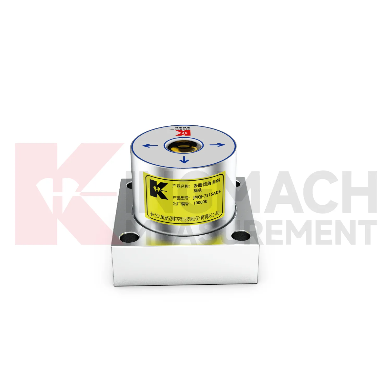
The JMQJ-7315ADS fixed tiltmeter is a key Kingmach Digital Traversing Inclinometer product for biaxial structural tilt monitoring. It uses MEMS technology, a high-precision acceleration integrated chip, differential measurement principles, 16-bit AD sampling, RS485 digital communication, a unique electronic code, and lightning protection design. The product is used to observe inclination angle change and deformation of bridges, buildings, railways, and other structures relative to the horizontal plane, including hidden parts that are difficult to observe by conventional methods. Published specifications include +/-15 degrees dual-axis measuring range, 0.001 degree resolution, 0.01 degree accuracy, DC 9V to 24V supply, power consumption below 0.5W, RS485 digital output, -30 degrees Celsius to +80 degrees Celsius operating environment, 55 mm by 55 mm by 46 mm dimensions, IP68 protection, and 0.6 kg weight.
Application of Digital Traversing Inclinometer
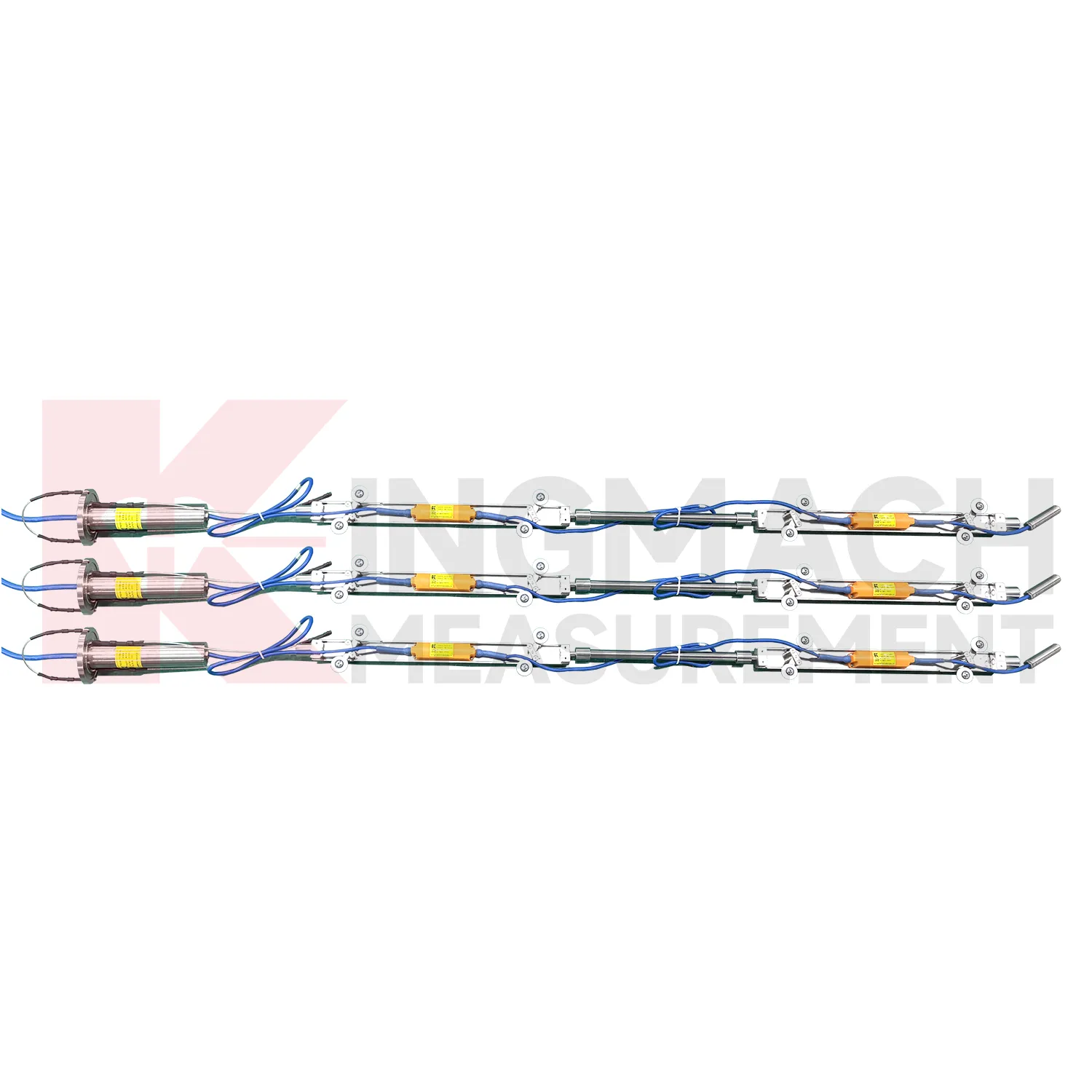
Slope and geological hazard monitoring use Digital Traversing Inclinometer to detect internal movement before the surface condition becomes clear. JMQJ-7915ATS is especially relevant because its multi-point in-place inclinometer string can observe deformation at different depths inside a borehole. JMZX-7100L can also be used for sliding inclinometer profiling in geotechnical slopes, dams, embankment slopes, and port engineering. Slope tilt or inclinometer data should be read with rainfall, groundwater, crack width, surface displacement, retaining structure movement, and construction disturbance. The key question is often depth: is the movement shallow, deep, or concentrated along one weak layer? A borehole profile with consistent point naming and stable orientation gives engineers better evidence for warning, inspection, and stabilization planning.
The future of Digital Traversing Inclinometer
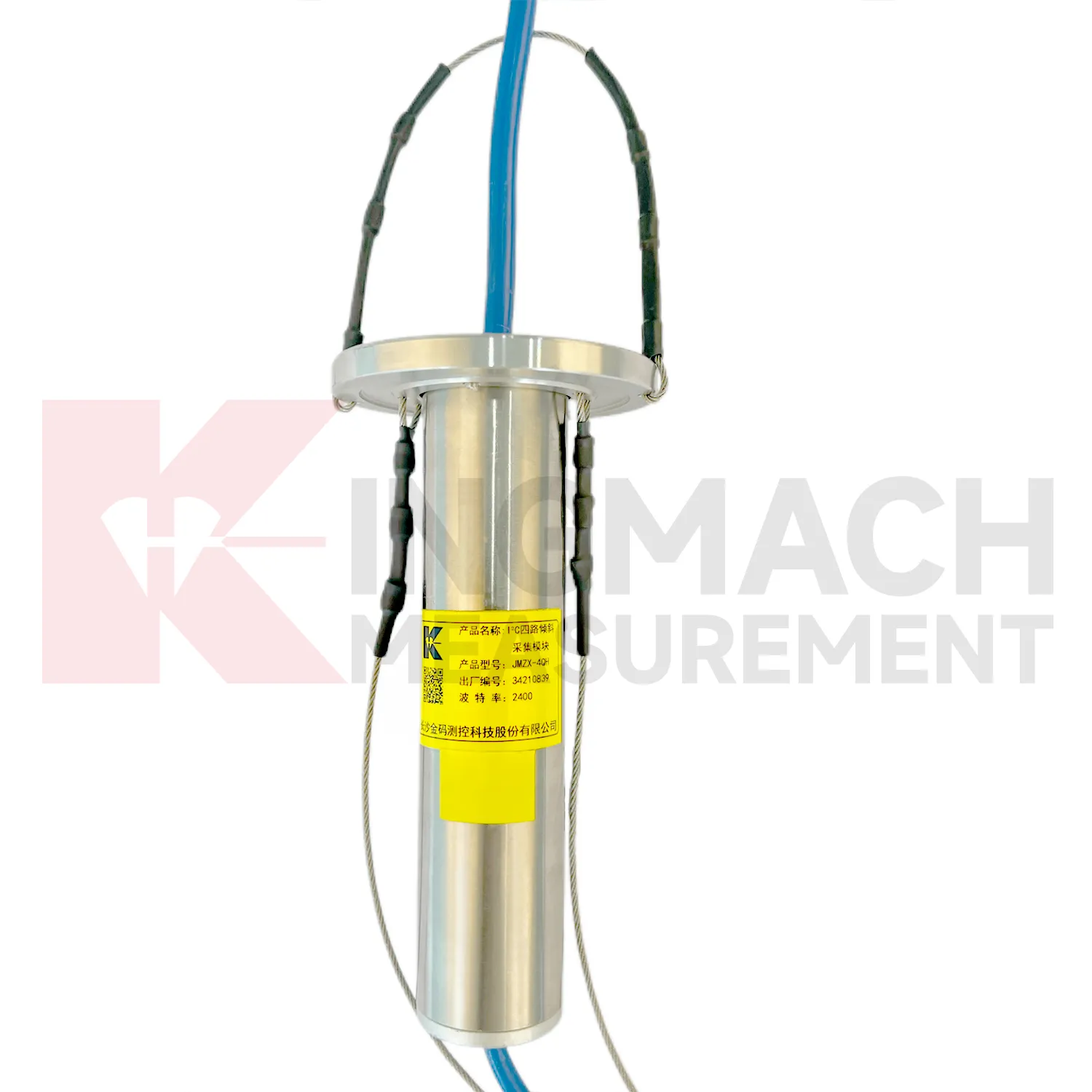
Multi-point borehole monitoring will continue to expand the role of Digital Traversing Inclinometer. JMQJ-7915ATS already connects multiple in-place inclinometer sensors through a single cable, with grouped communication, universal joints, connecting rods, electronic identifiers, and an orifice acquisition module. This type of system turns a borehole into a depth-based deformation profile rather than a single surface observation. Future improvements will likely focus on easier factory configuration, clearer point identification, lower power operation, and faster data review. Slopes, foundation pits, dams, embankments, and underground projects benefit from knowing where movement is happening inside the ground. Depth-specific tilt data can help teams move from general warnings to targeted inspection and reinforcement planning.
Care & Maintenance of Digital Traversing Inclinometer
Data review is part of maintaining Digital Traversing Inclinometer. A curve should be checked for rate, direction, sudden jumps, missing values, repeated flatlines, and disagreement with nearby instruments. Compare tilt with settlement, displacement, strain, load, pore pressure, rainfall, vibration, and water level when available. For automated systems, verify channel names, units, time stamps, and alarm thresholds after platform changes. For manual readings, keep raw field notes and processed graphs together. If an alarm appears, inspect the mounting point, communication path, recent site work, and related instrument behavior. A good maintenance process treats data quality and field condition as one record, not two separate tasks.
Kingmach Digital Traversing Inclinometer
For automated monitoring, Kingmach Digital Traversing Inclinometer can reduce the need for repeated manual survey work in hidden or hazardous locations. Fixed and integrated units can connect to acquisition systems, while in-place inclinometer strings can collect multi-depth data through an orifice module. JMQJ-7315RTU is designed for remote unattended automatic measurement using 4G wireless communication. JMQJ-7915ATS supports wired or wireless upload from the acquisition module, and its low-power mode activates sensors only during data measurement. These features matter where access is restricted by traffic, excavation, weather, or operating infrastructure. Automation does not remove the need for field checks, but it gives owners a continuous record that can be compared with rainfall, groundwater, blasting, train operation, loading, or nearby construction events.
FAQ
Q: What are Digital Traversing Inclinometer used for?
A: They measure angular change or internal deformation in bridges, buildings, railways, slopes, dams, foundation pits, tunnels, and other structures where tilt or deep movement must be monitored.Q: Which Kingmach model is used for fixed structural tilt?
A: JMQJ-7315ADS is a fixed MEMS tiltmeter with +/-15 degree dual-axis range, 0.001 degree resolution, RS485 output, and IP68 protection.Q: When is JMQJ-7315RTU useful?
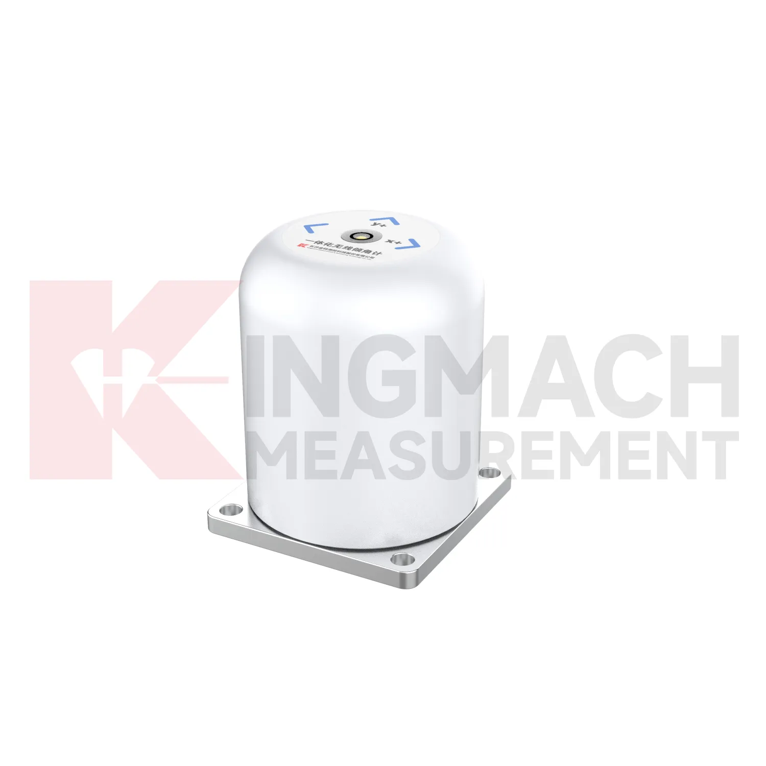
A: It is useful when wireless remote monitoring is needed because it combines MEMS tilt sensing, 4G digital output, and battery power.Q: What does JMQJ-7915ATS measure?
A: It measures multi-point inclination inside a borehole using a vertical in-place inclinometer string and an orifice acquisition module.Q: Can tilt data be used with other sensors?
A: Yes. It is often reviewed with settlement, displacement, strain, load, water level, rainfall, vibration, and inspection records.
Reviews
Matthew Garcia
Instrumentation cables are durable and perform well even in harsh environments. Will definitely order again.
Daniel Brown
Excellent environmental monitoring sensors. The data is consistent, and the system integrates smoothly with our existing setup.
Latest Inquiries
To protect the privacy of our buyers, only public service email domains like Gmail, Yahoo, and MSN will be displayed. Additionally, only a limited portion of the inquiry content will be shown.
Evelyn***@gmail.comSouth Africa
Hi, we are a contractor working on tunnel construction and need settlement sensors and displacement ...
Emma***@gmail.comCanada
Dear Sir/Madam, we are interested in displacement transducers and settlement sensors for a geotechni...